
I’ve been a fan of Greyhawk since the AD&D 2E days. The boxed set known as From the Ashes is my favorite Greyhawk product (with the Living Greyhawk Gazetteer a close second). Recently, The Piazza added a new Greyhawk sub-forum for the Chainmail setting. In the forum is a discussion thread (started in 2011) regarding the Southlands of Western Oerik and asks: why do official maps depict it as all desert?
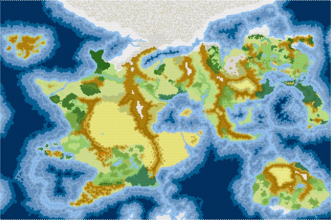
The post that caught my eye is a short one line post by ripvanwormer. He links to a map of Oerth created by Duicarthan that substantial reduces the desert lands. It is a map I’ve seen before, but seeing it again made me think, “that would make a great Hexographer map.”
So, I began the process last week. I turned Duicarthan’s map into a PNG file and imported it into Hexographer. I traced it the best I could and added a few elements to the map myself. I used several official Greyhawk maps to eyeball the river system for the Flanaess. (I was less exact for the rest of the world and didn’t add rivers on every landmass.) It came together quickly and I’m now done with it (see below).
I will now begin the process of heavily modifying the map for my own use. It will be tentatively be entitled “My Greyhawk.” I’m not sure what will will change but it will be substantial. I’ll likely completely redo all the river systems even those in the Flanaess. Of course, like with all my secondary projects, My Greyhawk will take a back burner to World of Kulan.
UPDATED: I’ve now imported the map in Hexographer II/Worldographer and modified it with the new version of the program. The resulting world map is more complete but since Worldographer allows for the creation of true child maps, any major changes I make to the Continent Level will alter the map below. Regardless, is basically complete.
Here is a link to the full-sized version.
Knightfall’s Greyhawk
